Newsletter Sign-up
Join our mailing list for news and events.
June 16, 2023
By Holly Harris, Konocti Regional Trails Volunteer.
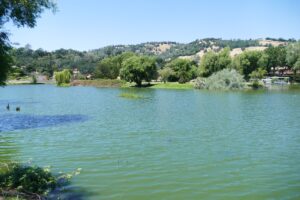
For the naturalist and those who want to savor breathtaking beauty, this is a scenic loop around Rattlesnake Island, past the historic Sulphur Bank Mercury Mine and wetlands, and back through the canals of “The Keys” in Clearlake Oaks. On calm days, this is an easy paddle for all levels. On windy
days, however, it is for experienced paddlers willing to battle heavy winds and large waves. In the summer, mornings are best since the midday sun can become intense and strong westerly winds typically pick up in the afternoon. Park and launch at the Clearlake Oaks boat ramp on Island Drive just off of East Highway 20.
Rattlesnake Island is considered by many to be one of the best fishing locations on Clear Lake, which is noted for largemouth bass and catfish. Most days, fishing boats dot the perimeter from sunrise to sunset.
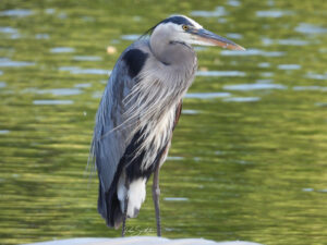
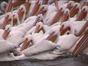
For birdwatchers, the winter months beginning in mid-December through March, can be an unforgettable paddling experience. Migratory groups of cormorants, grebes, gulls, coots, buffleheads, egrets, herons, and ducks are just a few of the waterfowl seen dotting the water, at times numbering in the tens of thousands. And it’s not unusual for lucky paddlers to see a ribbon display of several hundred American White Pelicans slowly soaring overhead.
But the summer still holds many resident waterfowl, including osprey typically perched on bare tree trunks. Families of otter and the occasional mink often play along the shoreline, as do the island’s resident goats and peacocks.
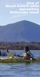
As you begin your paddle out toward Rattlesnake Island, Mount Konocti dominates the background—a dormant volcano that sits at an elevation of 4,300 feet. Geologists estimate its first eruption approximately 600,000 years ago and landslide activity since has created the shape along the flanks of the mountain we see today.
Archaeological evidence suggests Native American activity on Rattlesnake Island dates back 8,000 years. While privately owned, this island’s significance as the ancient burial ground and village site of the Elem Pomo, prompted a nomination to the National Register of Historic Places. Descendants of the early inhabitants live 500 feet east by Sulphur Bank.
Circling around the island’s eastern end, the historic Sulphur Bank Mercury Mine comes into view. Activity there dates back to the California gold rush days in the mid 1800s, when mercury was essential in the process of extracting gold from ore. Chinese laborers removed the ore from deep mine shafts, which changed to open-pit mining during the 1920s.
Over the decades, geothermal inflows and rainwater filled the pit, becoming highly acidic. The pit is higher in elevation than Clear Lake, and as water moves through the waste rock wall that creates the border between the two, mercury is slowly leaching back into the lake. When oxygen levels decline, specialized bacteria present in the sediment converts this to methyl mercury, which can be easily absorbed by wildlife and fish. The high levels of mercury prompted the mine to be designated an EPA Superfund Site in 1990. While few remnants of the mine or equipment remain, the location is a California historic landmark, although currently is fenced off to the public.
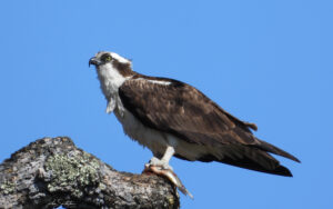
Heading back around the wetlands just north of the Elem Indian Colony, watch the shoreline. Osprey—and the occasional eagle—can be seen perched for prey in tall, bleached-out trees. Paddle past secluded Dollar Island and catch your breath by perching on one of the small rocky crags while you enjoy the view, but beware of poison oak. At this point, you can choose to head back toward the boat launch, but avid bird watchers may opt to paddle into the Keys to loop into a small tule marsh. In the morning, calling birds—such as blackbirds, coots, herons—overpower the sounds of motorists along nearby Highway 20.
Head back toward the boat ramp by entering the main Key near the campground at the southern tip of Stubbs Island. Keep heading to the left through the Keys and just before Clarks Island, a weeping willow hides the Island Drive bridge—you can choose to paddle under this to return to the boat ramp, or take a picnic break on Clarks Island, which is a County owned park. This loop is best done in the winter, spring, or early summer; naturally occurring algae, low water levels and aquatic weeds can hinder your paddling efforts during late summer and fall. On windy days, the Keys can be a nice, easy jaunt through the canals, or a great choice if you’ve finished with Rattlesnake Island but aren’t yet ready to stop. Great for waterfowl birdwatching, particularly in the winter.
This is one of a series of Lake County Water Trail brochures, published as a cooperative effort of the County of Lake and the National Park Service Rivers, Trails and Conservation Assistance Program.